All published articles of this journal are available on ScienceDirect.

Assessing Terrain, Vegetation Potential, and Climate Data of Emirates Sites through Soil, Location, Rainfall, and Weather Station Data Analysis
Authors Info & Affiliations
Abstract
Background
The Fujairah region is characterized by extremely arid land covered with rocky mountains and rocky soil, with minimal rainfall, presenting significant water availability challenges. A large portion of the globe lacks comprehensive soil data, even as soil knowledge becomes increasingly crucial in addressing environmental and food security concerns.
Methods
The imminent threats posed by arid soils, urban expansion, and vegetation depletion in the United Arab Emirates (UAE) are endangering the region's economy, well-being, community stability, and the preservation of the local ecosystem and wildlife. To address these challenges, this study focuses on three specific areas within the UAE: Al Taween, Al Taiba Farms (ATF), and Flag Park. These locations have undergone thorough examination to better understand their soil characteristics, topography, and reforestation potential. The international standard methods (United States Environmental Protection Agency, USEPA 9045 D, EPA 9253, USEPA 9050A) Kjeldahl Method, Titration, and ICP-OES, have been used for soil assessment.
Results
The field survey, soil characteristics analysis, average precipitation, temperature, and overall environmental conditions of all three sites in the Emirates indicate a poor agricultural potential at these locations. The assessment of temperature, wind speed, and rainfall has been done based on weather station data. It is assessed that with proper planning and strategic interventions, these lands can be effectively utilized for agricultural purposes.
Conclusion
This proposal outlines a gradual strategy that could be implemented throughout the UAE, serving as a foundational step for initiating vegetation and greening projects to mitigate the environmental challenges and resource constraints facing the region.
1. INTRODUCTION
For successful resource use, management, preservation, and conservation, it is crucial to have a thorough understanding of soil behavior and its distribution across the terrain [1]. From a global to a local level, the one missing information layer that has frequently caused uncertainty in projecting potentials and restrictions for agricultural production is soil knowledge (FAO/IIASA/ ISRIC/ISS-CAS/JRC 2008). A large portion of the world has relatively inadequate coverage of soil data, despite the fact that soil knowledge is becoming more and more necessary, especially in light of growing environmental and food security concerns [2].
In different countries, a variety of soil-analytical techniques are employed to determine the fertility state of soil. Frequently, a distinct extractant is utilized for nearly every nutrient. Research institutes, engineering organizations, and private laboratories conduct a multitude of chemical analyses to determine the fertility and contamination levels of soils across the globe. Methods of chemical soil testing are being standardized at this moment by the TC 190 ‘Soil Quality’ of the International Standardization Organization (ISO). Researchers often have to sum up, simplify, and communicate large amounts of complex data in a clear way [3].
There are enormous factors that affect the soil quality. In dry and semi-arid places where precipitation exceeds evaporation, soil salinization is one of the most prevalent land degradation processes [4]. Under such climatic conditions, soluble salts accumulate in the soil, altering the soil's characteristics and environment, ultimately resulting in a loss in soil production [5]. Soil salinization is a significant kind of land degradation in agricultural regions. The process of land degradation caused by the rate of soil loss exceeding the rate of soil formation has shaped the physical landscape of today. Soil erosion is one of the eight soil hazards highlighted in the European Commission's Soil Thematic Strategy, 2006. In recent years, soil contamination with harmful heavy metals has received a rising amount of attention due to the expansion of human activities and the industrial and transportation sectors. Not only has urbanization affected soil qualities in the immediate vicinity, but also at a distance. The majority of heavy metals are poisonous, persistent, and bioaccumulative. They have a tendency to accumulate in soils and to be transmitted to plant components, which act as bioaccumulators [6]. Consuming contaminated food has negative impacts on human health, particularly on children. The United States Environmental Protection Agency (USEPA) identified numerous heavy metals as dangerous air pollutants, including Pb, Co, Mn, Ni, Cd, and Cr, with Cd, Cr, and Ni being classified as carcinogenic [7]. Some soil functions and services may be degraded or lost due to chemical compounds and heavy metals. Almost all heavy metal pollution is irreversible [8].
The eastern and northeastern region of the country suffers a soil fertility crises that challenge its vegetation and ecosystem conservation, and with ongoing climate changes and rising temperatures, the region faces its greatest risks of increased aridity and desertification. The total area of the Emirate is about 1,580 square kilometres, representing 1.9% of the country's area. The mountains and rocky heights are about 1,200 square kilometres, representing 76% of the total area (Fig. 1) [9]. The urban areas and townships occupy about 15% of the Emirate's total area. The region's sandy soils, its high-water permeability rate, low water holding capacity, low water moisture content, poor nutrient availability, and low fertility rate are significant factors limiting its green cover and degrading its natural plant and animal habitats [10].
Like all arid regions, the city's water cycle is dominated by short-lived flash floods brought on by intermittent Rainfall. A great deal of that Rainfall runs into the sea and is never absorbed by soils or plants such that it supports life on the land (in some deserts, the amount of rain lost to the ocean is >90% of all Rainfall) [11].
The current and foreseen challenges of arid soils, urban expansion, and vegetation crisis are imminently threatening the community's economy, welfare, and stability and endangering the overall ecosystem conservation and natural life.
Due to the limited conventional water resources, a heavy dependency and reliance on non-renewable groundwater to meet the demands of the agricultural, industrial, and forestry sectors have been observed. Scientific studies have clearly shown a significant depletion of groundwater levels and increased salinity and created substantial concerns that groundwater will dry out and vanish in the long term [12]. Hence, managing scarce water resources and saving the water resources of seasonal floods and rainwater represents the most feasible and realistic roadmap to coop, adapt and mitigate future water scarcity threats [5, 13].
The aim of the study is the analysis of soil characteristics and their topography. Three main regions including Al taween, ATF, and Flag Park, were selected from the area of interest. The locations have been extensively investigated and assessments are made to enhance soil quality, water management, and vegetation expansion in these areas. This proposition provides a gradual approach that could be implemented in all of UAE. The study could be helpful in providing the initial stage to start vegetation and greening projects.
2. MATERIALS AND METHODS
A total of 6 soil samples were collected from three locations of interest in UAE, including Al Taween, ATF, and Flag Park. The samples quantity of 1kg each were collected from the upper 10 cm and 50cm layers each and stored in labelled polyethylene bags. In the laboratory, soil samples were ground, sieved through 2 mm mesh, and stored in plastic bags. 200 mg of material were digested in a dry and Teflon digestion beaker, and then 6 mL of HNO3, 2 mL of HCl, and 2 mL of HF were added. The mixture was then heated for 40 minutes at 120–150 °C on a hot plate. Whatman filter paper No. 42 was used to filter the combination, and the filtered digest was then transferred to a 50 mL plastic volumetric flask and filled to the prescribed level with deionized water. Agilent 700 series ICP-OES was used to measure metal content. The analytical measurement procedures were validated using a Certified Reference Material (CRM) (IAEA SOIL-7) [8]. Reagent grade chemicals are used for the analysis which conforms to the specifications of the Committee on Analytical Reagents of the American Chemical Society. Standard titration methods have been used to analyze the salinity, alkalinity, and chloride contents. In a white porcelain container, 50 mL or less of the sample containing between 0.25 mg and 20 mg of chloride ion was poured. The sample was diluted to roughly 50 mL with reagent water. pH was adjusted to the phenolphthalein endpoint (pH 8.3). Approximately 1.0 mL of K2CrO2 indicator solution was added and thoroughly mixed. Standard AgNO2 solution was added dropwise from a 25 mL buret. Further, the chloride ions were calculated. A 10 g subsample of soil was added to 25 ml of distilled water in a plastic beaker and stirred for 5 minutes. The pH of the soil suspension was then measured using a pH meter. A 10 g subsample of soil was mixed with 20 ml of potassium sulfate solution and digested with 10 ml of concentrated sulfuric acid in a Kjeldahl flask. The digested solution was then distilled and titrated with standardized hydrochloric acid to determine the total nitrogen content of the soil [14, 15]. A 10 g subsample of soil was extracted with 0.5 M NaHCO3 solution, and the extract was analyzed using a spectrophotometer to determine the available phosphorus content of the soil [16].
2.1. Climatic and Statistical Analysis
Maximum and minimum daily temperatures in Celsius (°C), precipitation in Milimeters (mm), and wind speed (km/h) for all sites have been mined and calculated on an online server Meteoblue (www.meteoblue.com).
Info graphical representation and comparison of the laboratory analysis between all three sites has been accomplished using Microsoft Excel.
3. RESULTS AND DISCUSSION
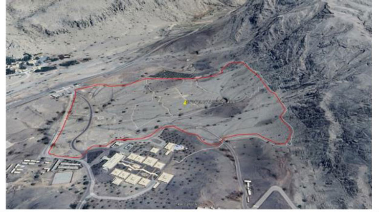
3.1. Assessment of the Al Taween Site
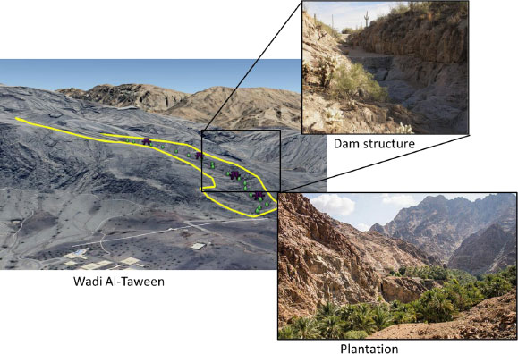
Al Taween (Fig. 2) is located within the coordinates 25°34'15.14” N and 56°5'27.49”E in the UAE, with a perimeter, of 2,057.58 m, and a total area of 178,664 m2.
3.2. Soil Characterization
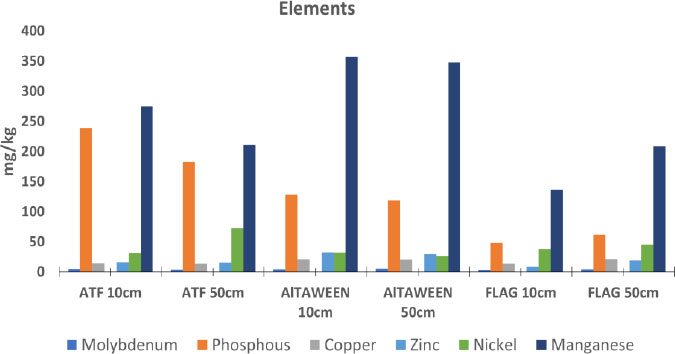
The soil properties of each site have been analysed. The 10cm and 50cm soil layers does not show a significant difference (Table 1). The soil type in Al-Taween is alkaline, hence porous [17]. For soil layers 10 cm and 50 cm, the measured alkalinity is 258 and 211 mg/kg, respectively. It also shows very little conductivity, which estimates a less nutritional potential of the soil for plantation. There is an increase in conductivity with depth; 325 S/cm was measured in a 50 cm layer, compared to 171 S/cm in a 10 cm layer. Iron and potassium concentrations have been measured at 20 g/kg and 24 g/kg, respectively, which are higher than other components analysed. Molybdenum (Mo) is an essential trace element that plays a crucial function in the development and growth of plants. Symbiotic nitrogen-fixing bacteria in legumes require it to fix atmospheric nitrogen and convert nitrate into nitrite and then ammonia before using it to manufacture amino acids within the plant. However, larger concentrations are deemed harmful. Globally, the average Mo content in arable soils is between 1 and 2 mg kg [17, 18]. Mo levels range from 4.9 to 5.5 in the 10cm and 50cm soil layers+ in Al Taween (Table 1 and Fig. 3). The solubility of molybdenum increases as the pH of the soil becomes more acidic. As indicated by the results, the pH of the soil is approximately 9, making it alkaline and affecting the absorption of this element by plants. High Mo concentrations stem from two sources: high concentrations in soil due to parent materials and contamination from pollution, such as mining wastes. Apart from soil analysis, On-site visits determine the large gashes and gullies at different parts showing easily eroding soil. Such nature of soil makes it difficult for plant roots to soak up necessary nutrients. Acidifying fertilizers that contain elemental sulfur like aluminum sulfate or ammonium sulfate or organic fertilizers can be used to enhance soil fertility.
| Test | Unit | Al Taween | ATF | Flag Park | |||
|---|---|---|---|---|---|---|---|
| - | - | Soil 10cm Layer | Soil 50 cm Layer | Soil 10cm Layer | Soil 50 cm Layer | Soil 10cm Layer | Soil 50 cm Layer |
| Nitrogen | % wt. | <1 | <1 | <1 | <1 | <1 | <1 |
| pH at 25˚C | _ | 8.9 | 8.8 | 8.02 | 8.29 | 8.02 | 7.93 |
| Iron | mg/kg | 20684.18 | 20139.67 | 43127.44 | 31728.54 | 12376.78 | 17199.09 |
| Copper | mg/kg | 21.11 | 20.41 | 14.57 | 13.88 | 13.81 | 21.59 |
| Potassium | mg/kg | 2375.15 | 1955.02 | 998.32 | 1033 | 1083.76 | 1083.76 |
| Molybdenum | mg/kg | 4.9 | 5.55 | 5.08 | 4.39 | 3.74 | 4.75 |
| Phosphorus | mg/kg | 128.42 | 119 | 239.01 | 182.9 | 48.03 | 62.03 |
| Chloride | % wt. | <0.1 | <0.1 | <0.1 | <0.1 | <0.1 | <0.1 |
| Zinc | mg/kg | 32.32 | 29.52 | 16.43 | 15.8 | 8.64 | 18.79 |
| Nickel | mg/kg | 31.77 | 26.95 | 30.77 | 73.15 | 38.5 | 45.36 |
| Boron | mg/kg | <0.05 | <0.05 | <0.05 | <0.05 | <0.05 | <0.05 |
| Salinity | ppt | 0.13 | 0.11 | 0.23 | 0.2 | 0.21 | 0.03 |
| Manganese | mg/kg | 356.77 | 348.26 | 274.86 | 211.13 | 136.66 | 209 |
| Conductivity at 25˚C | µS/cm | 171 | 325 | 1018 | 919 | 2165 | 2492 |
| Alkalinity | mg/kg | 258 | 211.5 | 113.54 | 104 | 97.18 | 83.66 |
3.3. Temperature and Rainfall
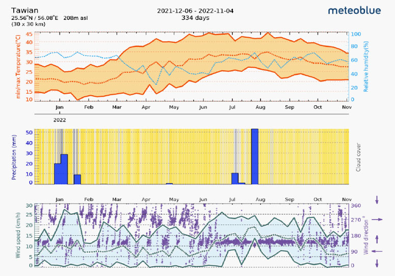
Data for 2021 and 2022 have been collected and analysed for temperature, precipitation, rainfall, and wind speed. During the months of May through August, temperatures in Al Taween typically rise to between 43 and 45 degrees Celsius on average (Fig. 4). The relative humidity decreased from April to June and remained above 60% throughout the year. Similarly, 30 mm of precipitation has been recorded for the month of January, with 50 mm being the highest recorded value for the month of August. The remainder of the year has observed little precipitation. Precipitation is one of the three major components of the global water cycle, with evaporation and condensation being the other two [19]. In addition, the average wind speed for this region during the first half of the year ranges between 14 and 20 kilometres per hour, with the exception of January, when it consistently exceeds 25 kilometres per hour. Moreover, later in the year exhibited the highest wind velocity. The annual rainfall is recorded as 76.2 mm which can provide up to 160,000 m3 of water each year as per calculations. Over the course of 18 years, from 2003 to 2021, we have also determined the average monthly total rainfall (in millimetres) (Supplementary Materials 1). The average rainfall for the months of January, March, and December is 20 mm, 14 mm, and 13 mm, respectively.
3.4. Recommendations for Afforestation in Al Taween
Based on field visits and collected soil, temperature, windspeed, and average annual rainfall, the water retention, plan for afforestation is proposed here. The system, if done correctly, can be useful in planting hundreds of more trees within this Wadi for greening, and animal or bee feed. The suggested are the plantation of native trees, such that extra water irrigation can be cut off after a few months. This arid land can be made arable using some of the check dam structures deployed in the watershed area of the Wadi. The system structure will help retain water and reduce flood severity. This is intended as a prototype for a system that can be deployed throughout other wadis in Fujairah, and eventually the UAE. AL Taween is a small wadi – not long enough for springs to emerge, but it is enough to demonstrate the utility of the broader system and begin training a team on its design and construction. The current estimate is for 7 check dams in the upper wadi and five in the lower wadi. Two Spack lines can be built to grant heavy machinery access to the upper wadi, provide stone for earthworks, and emergency access for teams and machinery in case of flash floods. Overflow points of each check dam should be level with the floor of the preceding check dam.
Together these earthworks will create planting spaces for hundreds of trees but will also catalyze the natural regeneration of the wadi, as long as it is protected from grazing animals. The water runoff and keeping in mind the average 7.5 liter of water requirement per tree in UAE, the area can be made suitable to plant 3300 to 3800 native trees planted in the Wadi. The illustration of the introduction of dams and plantations afterward has been explained in Fig. (5).
Construction should only occur when the risk of rainfall and flooding is low; having heavy equipment and personnel in wadis during the rainy season is a risk, and while the likelihood of being caught in a flash flood is low, the potential for severe damage or death, if someone is caught in one, is high. Once the system is operational, construction should occur during the dry season and planting should occur during the wet season. If building is to take place while there is a chance of precipitation, there must be a strategy for safeguarding both materials and personnel from flooding, as well as for rapid evacuation.
While it may seem difficult to bring the equipment to the top of the wadis first, doing so protects the investment and substantially decreases the chance of blowouts as the check dams fill with silt eroded by precipitation.
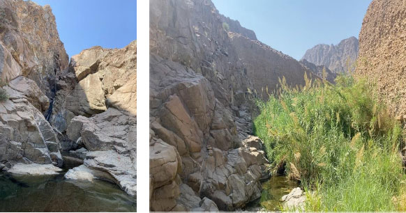
3.5. Assessment of the ATF Site
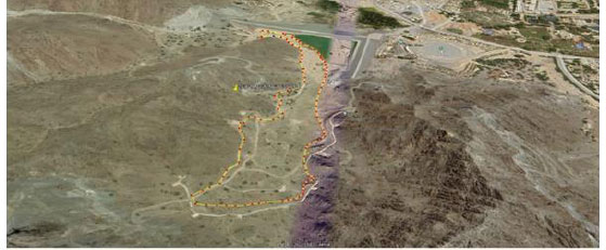
ATF studied site is located within the coordinates 25°8'15.32” N and 56°18'35.08”E with a total perimeter of 1,815 m and an area of 53,212 m2. (Fig. 6).
3.6. Soil Characterization
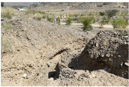
With a pH >8.0 and EC just below 100mS/m, ATF's soils are sodic, highly dispersive, and have low to moderate levels of bioavailable nutrients. During a field survey, the two contour ditches were found (Fig. 7). Both have been eroded and broken by possible rainfall. The soil’s high dispersion indicates the causes of the blowout along the contour ditch. The high pH likely inhibits the uptake of key nutrients. Thus, despite high quantities of iron (double the iron available in the Al Taween site), potassium, phosphorous, manganese, and others in the soils, the bioavailability of these minerals is likely very low. The highest value of Iron is observed in ATF followed by Altaween and then Flag Park (Table 1 and Fig. 3). The fertilizers must be used to enhance the fertility of the soil on this site.
3.7. Temperature and Rainfall
Temperature, precipitation, rainfall, and wind velocity data for 2021 and 2022 have been collected and analysed (Supplementary Material 2). During the months of April through September, the average temperature in ATF is between 45 and 50 degrees Celsius. From mid-March to June, the relative humidity decreases to 10 to 20%, while remaining above 60% for the majority of the year. The precipitation total for the month of January does not exceed 10 millimetres. Nevertheless, in August it exceeded 35mm. Less than 10mm of precipitation was recorded for the remainder of the year. In addition, during the first half of the year, the average wind speed in this region ranges between 18 and 40 kilometres per hour, with the exception of mid-January, when it consistently exceeds 58 kilometres per hour. In addition, later in the year, the wind speed was less than 25 kilometres per hour. According to calculations, 80 millimetres of annual precipitation can supply up to 34,400 cubic metres of water annually. We have also calculated the average monthly total precipitation (in millimetres) for the 18-year period from 2003 to 2021. (Supplementary Materials 3). The average precipitation for January, March, and December is 10, 15, and 17 millimetres, respectively.
3.8. Recommendations for Afforestation ATF
The proposed afforestation recommendations are based on field trips and collected soil, temperature, wind speed, and average annual precipitation data. Two broken contour ditches demonstrated that further ditches are unnecessary. All drainage is captured by the dam below, thus repairing the ditches will not assist. Since Moringa peregrina appears to grow directly from rocky cliff faces, this tree could be recommended for propagation. There is a requirement for pumps and temporary irrigation. Numerous hectares of slope are suitable for reforestation using Moringa peregrina, and trials with additional native plants are recommended. Establishment requires drip irrigation, although it can be discontinued later. Planting seeds in January or February and applying drip irrigation for 120 days can be beneficial for the plantation. Mulch plantings to lower soil temperatures, encourage soil biota, and prevent evaporation. This improves the efficiency of drip irrigation greatly. Due to the strong wind velocity in this area, rock mulching is recommended over straw mulching. In arid regions, mulching can reduce soil temperatures by 30 degrees Celsius.
3.9. Assessment of The Flag Park Site
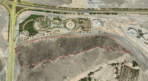
The Flag Park site (Fig. 8) is located within the coordinates 25°7'12.78”N and 56°17'7.87”E in the UAE, with a perimeter are 1,571 m, and the total area is 70,704 m2.
3.10. Soil Assessment
According to the soil analysis, the values of iron, phosphorus, zinc, nickel, and manganese are higher in deep soil layers than in the top 10 cm layer of soil. Similarly, there is a higher amount of copper in the 50cm soil layer than the 10cm layer with a difference of around 8 mg/kg. The high conductivity and higher salinity are likely the result of irrigation. The 50 cm soil layer started to show lower salinity than the top layer. Manganese and phosphorus are observed to be elevated in all three visited locations. The analysis depicts that these soils are sodic and thus highly dispersive and erosive in rainfall and flash floods (Table 1).
3.11. Temperature and Rainfall
Temperature, precipitation, rainfall, and wind speed values for 2021 and 2022 are listed in. (Supplementary Materials 4) The majority of the year has temperatures above 45 degrees. While the air is humid year-round, it is especially dry during the peak of the summer season, which is May and June. It rains an average of less than 10 millimetres every month aside from the month of August, when it can reach above 30 millimetres. Analysis suggests that windy conditions persist throughout the year. Given the average yearly precipitation of 137.4 millimetres, the total water output from rainfall can reach 10,000 cubic metres (Supplementary Materials 5).
3.12. Recommendations for Afforestation in Flag Park
Field surveys have revealed a number of eroding areas, most likely the result of a combination of erodible soil and excessive rainfall. An assessment suggests that terracing the hillside might be an expensive undertaking with long-term benefits for slope stabilisation, erosion prevention, and aesthetic enhancement of the park. Native tree species could potentially be planted there.
CONCLUSION
The field survey, soil characteristics analysis, average rainfall, temperature, and overall environmental conditions of all three sites in the Emirates reveal a dismal potential for agriculture at these locations. However, the key lies in the implementation of a well-thought-out strategy. The suggestions for each location, including soil upgradation techniques and water harvesting techniques, play a pivotal role in achieving the long-term goals of sustainable agriculture and ecological restoration. When properly executed, such a strategy can yield sustainable results that are expected to have a lasting impact for generations to come. Scaling up these initiatives could lead to the rejuvenation of natural springs, an increase in water resources within the mountains, extensive reforestation efforts, and the revival and expansion of vegetation and wildlife in these regions. It is worth noting that these suggestions are currently being put into practice in the Fujairah region. While the transformation and recovery processes may take some time to yield significant outcomes, we remain committed to monitoring and documenting progress. In the future, we intend to compile the results into a follow-up publication to share the tangible successes and lessons learned from these efforts.
LIST OF ABBREVIATIONS
| UAE | = United Arab Emirates |
| ATF | = Al Taiba Farms |
| CRM | = Certified Reference Material |
CONSENT FOR PUBLICATION
Not applicable.
AVAILABILITY OF DATA AND MATERIALS
The soil data is collected by our team via filed survey and laboratory analysis. The temperature, wind and precipitation related data has been accessed from Meteoblue portal (https://www.meteoblue.com) and rainfall data was collected from NCM online server (National Center of Meteorology - Climate Yearly Report (ncm.ae)). The rainfall information has been updated in the research paper now.
FUNDING
None.
CONFLICT OF INTEREST
The authors declare no conflict of interest financial or otherwise.
ACKNOWLEDGEMENTS
Declared none.
SUPPLEMENTARY MATERIALS
Supplementary material is available on the Publisher’s website.