All published articles of this journal are available on ScienceDirect.

GIS-based Land Suitability Evaluation for Sesame (Sesamum indicum L.) Production using Agro-climatic Indices in the Semi-arid Areas of Tigray
Abstract
Introduction:
Climate is the most important factor in determining crop production systems in Ethiopia. However, land suitability evaluation using climate variables for specific crops has been barely conducted to demonstrate the suitability of a location for the growth and yield of the crop. This study was, therefore, conducted to analyze land suitability evaluation for sesame production using agro-climatic variables by employing a multi-criteria approach.
Materials and Methods:
Temperature (maximum, minimum, and average temperature), annual rainfall, elevation, slope, growing degree days (GDD), and length of growing period were classified, and re-classified. Finally, a suitability map overlay was produced using ArcMap version 10.3.1
Results and Discussion:
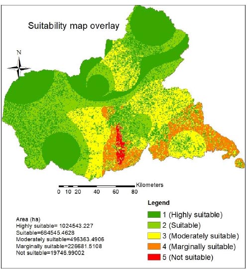
The results indicated that areas with higher elevations, like Adi Remets being 1860 meters above sea level, were classified as moderately suitable, whereas the majority of the study area was suitable for sesame production. After re-classifying the climate variables, elevation, and GDD, a suitability map overlay was produced for sesame production. The overall suitability map showed that areas around Humera, Dansha, Sheraro, Badime, Adigoshu, and some parts of Dedebit, Adiremets, and Maygaba were found from highly suitable to suitable, with 1,024,543.2 and 664,545.5 hectares of land, respectively. There has been no evidence with regards to land suitability classification for sesame production in the study area; hence, the results obtained in this study demonstrated the majority of the cultivated areas in the western and northwestern zones of Tigray to be high to moderately suitable for sesame production.
Conclusion:
Based on the results, a land suitability map representing a homogenous environment for improved sesame production was produced using a multi-criteria approach in the northwestern and western zones of Tigray. While the results obtained in this study might be helpful for agricultural experts, researchers, decision-makers, and farmers for crop intensification and expansion strategies, they can explicitly help in decisions in the marketing processes with respect to the crop’s value chain and provide a homogenous environment in the study area.
1. INTRODUCTION
Agriculture is the backbone of the Ethiopian economy, and the sector predominantly depends on rainfall, which is frequently affected by fluctuations [1]. Water shortage and extreme weather during cropping season may cause crop loss, and reduce land suitability for crop production [2].
Sesame is the second most exported commodity next to coffee in Ethiopia. It grows in a wide range of agroecologies, from hot to warm areas, and suitably under well-drained soils [3, 4]. In Ethiopia, the crop is cultivated in the Gambella, Amhara, Oromia, Southern Nations, Nationalities and People, and Benshangul Gumuz, and Tigray regional states.
Ethiopia is the eighth sesame producer, both in terms of production and area coverage, in the world, and the third producer next to Nigeria and Sudan in Africa [5]; it obtained the highest revenue of USD 693.5 million in the world market in 2015 [6]. The total production and total area coverage of sesame in the 2016 cropping season in Ethiopia were 274217.4 tons and 388,245.5 hectares, respectively [7]. According to the Ethiopian Central Statistical Agency (CSA) report, a total of 74,661.46 tons of sesame seeds were harvested from 122,325 hectares of land in western and northwestern zones of Tigray during the 2018 main cropping season, which created jobs for 145,847 farmers during the production season [7]. The average yield of sesame in Tigray was 0.57 tons, and 0.71 and 0.54 tons in the northwestern and western zones of Tigray in the 2016 cropping season [8].
Agroecological zoning involves the inventory, characterization, and classification of environmental resources [9]. Recent studies on climate land suitability analysis provide information on management, climate change adaptation, and decision-making on policy implications under a given agroecology [10-12].
Land suitability evaluation (LSE) is a process for matching the characteristics of land resources for certain uses employing scientifically standardized techniques and taking into account the degree of appropriateness of land for a certain use [13]. Land suitability analysis has been conducted by employing a multi-criteria approach using agroecological and climate variables in different parts of the world, for example, coffee [10], maize [14], tea [11], and wheat [15]. Land suitability is the capability of a given soil or land to support a defined use; it involves different interdisciplinary approaches, like crop science, soil science, social science, meteorology, economics, and management [16]. Land suitability evaluation for crop production can be applied based on climatic parameters, soil characteristics, topographic properties, and natural hazards [17]. Nowadays, new spatial analysis technologies, like geographic information systems (GIS) and remote sensing, and multi-criteria decision-making approaches, such as analytical hierarchy process (AHP), and fuzzy AHP, can be used for improved land suitability evaluation [11, 17].
Despite their determinant effects on crop growth and yield, climate variables have been rarely considered for land and agroecological suitability evaluation and mapping. Under the increasing climate change impacts on agriculture, land suitability analysis on soil-climate-landscape [18] is essential for improved climate change adaptation and crop management strategies. It has also been stated that agro-climatic indices are potential indicators of climate change's impact on crop growth [19]. Understanding the likely impacts of climate change on agricultural production is of paramount importance for developing long-term policy [2]. The thermal regime is a basic climatic parameter used to define a specific agroecological zone, with a temperature interval of 5ºC to 2.5°> C [9].
Temperature and rainfall suitability analysis through GIS-based multi-criteria provides an assessment of temperature and rainfall potential for winter wheat and summer maize cropping systems in China [12]. Similarly, studies have also reported conducting land suitability evaluation for determining surface irrigation potential in Ghana using GIS-based multi-criteria [20, 21], and highlighted that the analysis envisages the potential areas for suitable irrigation systems using groundwater potential under present and future climate projections. A more comprehensive analysis of land suitability was conducted for wheat, sugar beet, and maize, and it was based on daily minimum, maximum, and optimum temperature, annual rainfall, and growing degree (GDD) at different growth stages [20], and the parameters were found best for identifying agro-ecological suitability on the Mashhad plain in Iran. Such agro-climatic parameters have a high potential for determining the potential of specific agroecology for crop growth and productivity, especially in determining climatic and weather variables. To understand the impact of climate change on oil palm in Ghana [22], land suitability analysis was employed to map potential areas using a multi-criteria approach; it was highlighted that such assessment provides evidence for governments and policymakers regarding oil palm crop intensification strategies.
Similar studies on land suitability evaluation have been conducted in Ethiopia for irrigated vegetables [23], potato [24], wheat, faba bean, barley [25], sorghum [26], and other major field crops and fruits [27]. Similarly, land suitability evaluation was also carried out in the Andit Tid Watershed, in Ethiopia, for wheat and barley using a multi-criteria approach [28]. However, the above-mentioned studies were conducted mainly based on soil and topographic characteristics in different areas of Ethiopia, without considering climatic parameters, which are significant determining factors for crop growth and yield.
The process of assessing the suitability of an agricultural land for crop production requires specific agro-environmental information and computational expertise to analyze and interpret that information [29]. Hence, in this study, we applied long-term climate data to analyze land suitability evaluation and mapping in the study area. Besides, research studies conducted in different areas of Ethiopia have concentrated on mid to highland areas of the country, with less focus on lowland semi-arid areas, where erratic rainfall affects crop yield. It has also been noted a research gap in investigating land suitability for the most important agricultural commodities, like coffee and sesame, which are predominant export commodities. Moreover, the abovementioned studies have focused on land suitability evaluation based on soil’s physical and chemical properties, with less emphasis on climate variables.
The western part of Tigray is a potential area for sesame, cotton, and sorghum crops, which are very important cash crops. However, there has been little quantitative evidence on climate, soil, and agroecological suitability evaluations for the aforementioned crops. The oilseed sector is the second most important agricultural sector, both in terms of foreign currency earning and supporting the national GDP in Ethiopia [30]. Shreds of evidence indicate that climate change and variability might have a considerable impact on the growth and yield of crops, like cotton [31]. There is also evidence of land suitability classification for sesame production in different areas of Ethiopia [32]; however, the study has hardly shown explicit land suitability evaluation approaches. Hence, agroecological suitability evaluation may help identify homogenous environments for improved sesame production and marketing systems. This study was, thus, conducted to analyze land suitability and produce a land suitability map using long-term climate data and agroecological indices for sesame production in the semi-arid areas of Tigray.
2. MATERIALS AND METHODS
2.1. Description of the Study Area
The study was conducted in the western and northwestern zones of Tigray (Fig. 1). The study area consisted of six districts (woredas) as follows: Kafta-Humera, Welkayit, Tsegedie, Tahtay-Adiyabo, Asgede-Tsimbla, and Tselemti. Sheraro, Badime, Dedebit, and Maytsebri from the northwestern zone, and Adigoshu, Maygaba, Humera, Dansha, and Adiremets from the western zone of Tigray, were selected where sesame is widely produced as a major commercial crop. The study area was between latitudes of 14.72º> to 13.54º> North to 36.62º> to 38.143º> East longitude, with elevation ranging from 590 meters above sea level at Humera to 1350 meters above sea level at Maytsebri.
The study area was bordered by Eritrea in the north, the Sudan in the west, and the Amhara region in the south, and southwest directions. Mixed agriculture is predominantly practiced in these areas, with livestock, crop production, and forestry as the major livelihoods of the farming community. Sesame, sorghum, and cotton are the major cash crops cultivated in the area in the western zone, with soybean and cowpea cultivated as rotational crops. Crops, like finger millet, teff, rice, sesame, and maize are cultivated as major crops in Tselemti, Asgede-Tsimbila, and Tahtay-Adiabo woredas.
The climate of the study area is classified as hot to warm semi-arid lowland, with unimodal rainfall patterns [33]. The total annual rainfall varies from 630 to 960 mm per annum. The average maximum and minimum temperatures vary between 30 to 33°> C, and 20°> C to 23°> C, respectively [34]. Areas around Adigoshu, Adiremets, Badime, Dansha, Dedebit, and Sheraro have a semi-arid climate, whereas Maygaba and Maytsebri have dry sub-humid climate. The majority of the soil in the study area is dominated by black clay-type soils (vertisols) [35].
2.2. Methodology
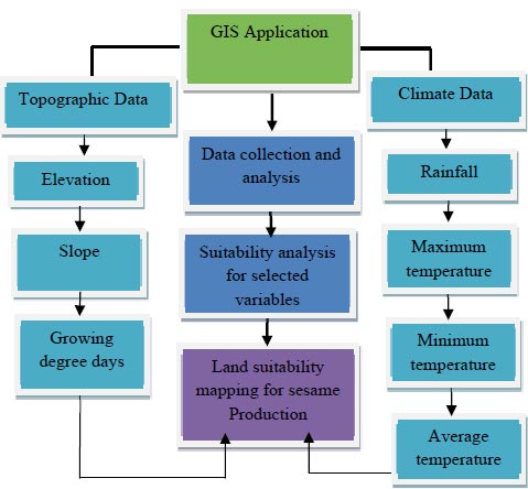
A quantitative land suitability evaluation approach was developed to conduct crop-specific climate and topographic suitability evaluation in the study area. The FAO NewLocClim software and ArcMap 10.3.1 software were mainly applied to compute the length of the growing period and carry out suitability classification analysis, respectively. In this study, a geographic information system (GIS) approach was applied to establish a spatial inventory of land resource databases in order to evaluate the potential areas suitable for sesame production in western parts of Tigray. We analyzed the land suitability evaluation step by step over the different layers, and finally produced the land suitability overlay.
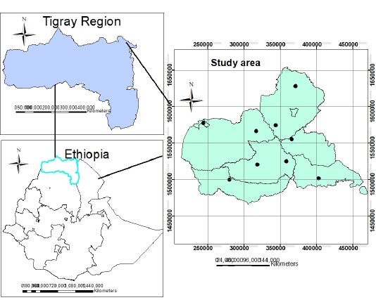
In this approach, we selected nine observation stations in five districts (woredas) from the two zones, and we prepared location-specific geospatial variables (elevation and slope) and climate data. Adiremets, Adigoshu, Badime, Dansha, Dedebit, Humera, Maygaba, Maytsebri, and Sheraro were selected due to the fact that the sesame crop is widely cultivated as a major field crop in these areas (Table 1).
2.2.1. Methodological Approach to Land Suitability Evaluation
In this study, we assessed long-term climate data, elevation, length of growing period, and growing degree days. Appropriate datasets were prepared for ArcMap and, finally, suitability maps were analyzed for separate criteria and the land suitability map overlay. The data were compiled in a CSV format for ease of importing data to the ArcMap GIS user interface, and we analyzed a step-by-step spatial analysis approach using a weighted overlay interpolation (Fig. 2).
2.2.1.1. Determination of Length of Growing Period (LGP)
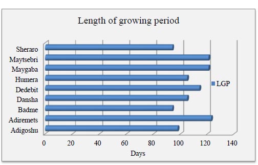
The agro-climatic potential of a land depends largely on the number of days within the year when the temperature regime and moisture supply are conducive to crop growth and development [36]. The length of the growing period is the period during the year when the rainfall exceeds half of the potential evapotranspiration (PET), and the period required to evapotranspire up to 100 mm of water from excess rainfall assumed to be stored in the soil profile [37]. The length of the growing period for each station (Fig. 3) was generated by selecting location by coordinates, except for Humera, which is available in the NewLocClim database.
| Weather station | Elevation (m) | Latitude | Longitude | Wereda |
|---|---|---|---|---|
| Adigoshu | 1115 | 14.16 | 37.31 | Kafta-Humera |
| Adiremets | 2014 | 13.75 | 37.32 | Welkayit |
| Badme | 1061 | 14.72 | 37.80 | Tahtay-Adiabo |
| Dansha | 780 | 13.54 | 36.97 | Tsegedie |
| Dedebit | 897 | 14.06 | 37.76 | Asgede-Tsimbla |
| Humera | 590 | 14.58 | 36.62 | Kafta-Humera |
| Maygaba | 914 | 13.79 | 37.69 | Welkayit |
| Maytsebri | 1350 | 13.58 | 38.14 | Tselemti |
| Sheraro | 1031 | 14.24 | 37.55 | Tahtay-Adiabo |
2.2.1.2. Growing Degree Days (GDD)
Growing degree days refers to the amount of heat energy of an organism, which is accumulated over a period of time in its lifecycle; this parameter relates to the plant growth, development, and maturity under the air temperature of a specific area [38]. Hence, in this study, GDD was calculated for each station using equation 1 and is presented in Table 2.
 |
(1) |
Where, Tmax is the daily maximum temperature, Tmin is the daily minimum temperature, and Tbase is the base temperature of the crop. The base temperatures for tropical crops are higher, and the Tbase for sesame was considered as 11°> C. Land suitability evaluation was carried out based on GDD in nine observation stations in the western and northwestern zones of Tigray, where sesame is commonly cultivated as a major crop.
2.2.1.3. Elevation and Slope Map Acquisition
The digital elevation model (DEM) of the study area was obtained from the Ethio-GIS Maps Administration Agency. Elevation and slope gradient for the study area were extracted from the Ethiopian digital elevation model (DEM) raster step-by-step approach.
2.2.1.4. Selection of Climatic Indices and Data Analysis
Daily climate data on minimum temperature, maximum temperature, and rainfall were selected from 1983 to 2016. Long-term observed climate data of some stations were not available from the National Meteorological Agency of Ethiopia, and for some stations, there was no complete set of data. To complement the ground data and fill in missing data from the stations, climate data were obtained from the National Aeronautic Space Administration (NASA) [http://power.larc.nasa.gov/common/AgroclimatologyMethodology/] [39]. Each parameter was analyzed over the time series following the procedures described earlier [34]. The average temperature was computed as the mean of the maximum and minimum temperature for each station. Selected climate parameters were organized in compatible formats for analysis using ArcMap 10.3.1 software.
| Station | Elevation | Annual rainfall (mm) | Tmax (°> C) | Tmin (°> C) | Tav (°> C) | LGP (days) | GDD (°> C) |
|---|---|---|---|---|---|---|---|
| Adigoshu | 1040 | 633 | 33.33 | 23.34 | 28.33 | 98 | 1705.15 |
| Adiremets | 1860 | 960.38 | 32.77 | 19.8 | 26.28 | 123 | 1514.50 |
| Badime | 1040 | 626.2 | 32.8 | 20 | 26.4 | 94 | 1525.2 |
| Dansha | 740 | 863.7 | 33.9 | 21.4 | 27.65 | 105 | 1641.45 |
| Dedebit | 960 | 719.4 | 31.5 | 19.9 | 25.7 | 114 | 1460.1 |
| Humera | 580 | 864 | 33.9 | 21.4 | 27.65 | 105 | 1641.45 |
| Maygaba | 860 | 903.6 | 30.3 | 18.2 | 24.25 | 121 | 1325.25 |
| Maytsebri | 1300 | 719.4 | 31.5 | 19.9 | 25.7 | 121 | 1460.1 |
| Sheraro | 1000 | 726 | 31.5 | 19.9 | 25.7 | 94 | 1460.1 |
Tmax, maximum temperature; Tmin, minimum temperature; Tav, average temperature.
Climate data on maximum temperature, minimum temperature, and daily rainfall were obtained from the National Aeronautic Space Administration (NASA) [http://power.larc.nasa.gov/common/AgroclimatologyMethodology/] [39] to fulfill the missing data for the observed historical data. In all stations, the observed historical data were limited for trend analysis. The average temperature for each station was computed as the mean of the maximum and minimum temperatures. The maximum temperature, minimum temperature, and annual rainfall considered in this study have been summarized over the years 1983 to 2016 (Table 2). In addition to long-term climate variables, data on elevation and length of growing period were also collected. Data on the length of the growing period for each station were analyzed using the FAO NewLocClim software. After creating appropriate datasets for analysis, data were imported to the ArcMap as a layer displayed over the western Tigray layer, and finally, interpolation was carried out using the IDW approach.
Tmax, maximum temperature; Tmin, minimum temperature; Tav, average temperature.
2.2.1.5. Suitability Classification and Map Overlay
After selecting each criterion, the maps were standardized based on the FAO suitability classification [37] into suitability classes (Table 3). All criteria were separately analyzed for their suitability for sesame production. The elevation, slope, LGP, maximum temperature (Tmax), minimum temperature (Tmin), average temperature (Tav), rainfall, and growing degree days (GDD) maps were developed using an inverse distance weighting (IDW) interpolation approach. To evaluate crop-specific climate suitability on the basis of phenol-phase-specific climatic indices, a weighted average could be derived from the index-specific suitability value S. The evaluation functions were applied at the local scale, and routine observations were carried out for all stations.
Selected variables/criteria have different measurement units, which requires a criteria standardization rating system. Thus, a weighted overlay method was applied to classify the suitability map of the study area by combining the selected variables. Before producing the suitability map overlay, re-classification of each variable was carried out to produce a combined suitability class overlay of the study area by standardizing it into equal interval approaches. This approach provides an opportunity to classify the contribution of the variables or criteria for the specified land suitability evaluation.
3. RESULTS AND DISCUSSION
3.1. Elevation
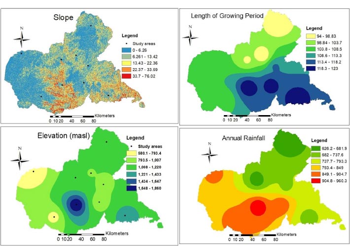
The results of the land suitability evaluation (Fig. 4) have indicated areas around Humera and some parts around Dansha as highly suitable for sesame production with elevation ranging from 580-793 meters above the sea level. The majority of the areas around Humera, some parts around Dansha, and areas around Dedebit, Sheraro, and Maygaba have also been classified as suitable with elevation varying from 793.5-1007 meters above the sea level. On the other hand, areas around Badime, Sheraro, Dedebit, Maytsebri Maygaba, and Adigoshu were classified as moderately suitable for sesame production, where the elevation in most of the areas was below 1500 meters above sea level. However, areas around Adiremets were classified as not suitable for sesame production with elevation varying from 1648-1860 meters above sea level; the areas where the elevation is 1700 meters above sea level are not considered suitable for the growth and yield of sesame. In this view, it has also been stated that sesame can suitably grow in areas with elevation ranging from 300 to 1700 meters above sea level [4].
3.2. Slope
The study areas varied in topography. Slope is one of the most important limiting factors for the growth and yield of sesame. The slope gradient in the study areas varied from 0 to 76 degrees (Fig. 4), where flat lands, hills, and mountains were found. Areas with higher slopes are mainly hills and mountainous, hence not suitable for sesame production. Areas around Humera, Dansha, Badime, Sheraro, and some parts around Dedebit, Maygaba, and Maytsebri were classified as flat lands with slopes ranging from 0 to 6.26 degrees. Areas around Adigoshu, Sheraro, Dedebit, and some parts around Badime, Dansha, and Maytsebri having slopes ranging from 6.26 to 13.4 degrees were relatively suitable for the use of tractors and combine harvesters, and hence suitable for sesame production. Fig. 4 illustrates that areas around Adiremts and Maytsebri and some parts around Adigoshu and Maygaba consisted of higher slopes varying from 22.37 to 76 degrees involving hills and mountains, and thus not suitable for tractors and other machinery. According to the FAO land suitability classification, areas with slopes above 20º> are not suitable for field crops [9] and other types of machinery for cultivation and harvesting.
| Suitability class | Definition |
|---|---|
| S1 | Highly suitable |
| S2 | Suitable |
| S3 | Moderately suitable |
| S4 | Marginally suitable |
| N | Not suitable |
3.3. Length of Growing Period (Days)
The results regarding the length of the growing period (LGP) revealed the LGP in the study area to vary from 94 days in Adigoshu, Badime, and Sheraro to 123 days in Adiremets, Maygaba, and Maytsebri (Table 2 and Fig. 3). The results showed areas around Humera and Dansha to be classified as highly suitable with the LGP varying from 105 and 114 days, respectively, where the onset of rainfall is in early July. The land suitability map with respect to the LGP (Fig. 4) indicated areas around Maygaba and Maytsebri to be moderately suitable where the LGP was above 121 days. In these areas, medium-to-late maturing varieties of sesame could suitably grow, while varieties with short duration might be affected by the unprecedented rainfall during their physiological maturity, and subsequently, harvesting and postharvest losses might occur. These losses include shattering and poor-quality seeds. On the contrary, in areas around Badime and Sheraro, where LGP is below 100 days, early cessation of rainfall might occur, which might cause water stress during the late growth stages before the crop reaches physiological maturity.
3.4. Rainfall (mm)
The results from the spatial interpolation IDW (Fig. 4) showed high rainfall in areas around Humera and Adiremets, and some parts around Dansha and Maygaba, ranging from 849-960 mm, whereas, areas around Badime, Adigoshu, Sheraro, and in some parts around Maytsebri, the rainfall was revealed to vary from 626 to 682 mm, thereby being highly suitable for the growth and development of sesame. However, there was an intermediate rainfall distribution in areas around Humera, small portions of Maygaba and some parts of Dansha, and areas around Dedebit and Maytsebri. Sesame can suitably grow in areas receiving an annual rainfall of 625-1100 mm, with the optimum rainfall varying from 500-650 mm per annum [4], provided that the soil is well drained. However, areas with high and low rainfall distribution may have a negative impact on the growth and yield of sesame, which may cause waterlogging, and times of prolonged rain spells may cause poor seed quality and postharvest losses, with the latter also causing soil moisture stress, respectively. High rainfall areas in Maygaba and Adiremets may cause blight disease infestation, poor seed quality, and postharvest losses. In the majority of the study areas, the total annual rainfall was found suitable for the growth and yield of sesame; however, the spatial and temporal distribution of rainfall patterns varied from place to place, which subsequently might affect the growth and yield of the crop. Also, spatial and temporal variability of different climatic variables has been observed [34], which was in agreement with the results obtained in this study. Another study conducted in the western zone of Tigray also indicated slight variability in annual rainfall around Dansha, substantially affecting the growth and yield of cotton [31]; this has been found similar to the findings obtained in this study.

3.5. Temperature
3.5.1. Maximum Temperature (Tmax)
Results of the spatial interpolation of maximum temperature (Fig. 5) revealed the highest maximum temperature in Humera, Dansha, and Adiremets, whereas the smallest maximum temperature was observed in areas around Maygaba, with temperature varying from 30.3-30.9°> C. On the other hand, the average annual maximum temperature around Badime and Sheraro, and in some parts around Adigoshu and Adiremets varied from 31.5-32.7°> C. Fig. 5 illustrates that the maximum temperature around Humera and Dansha and in some parts around Adigoshu and Badime varied from 33.7-33.9 °> C, which is a highly suitable temperature range for sesame, and in areas around Sheraro, Badime, and Adiremets, the maximum temperature varied from 32.11-32.7 °> C; thus, these were also considered suitable. Areas around Dedebit and Maytsebri were classified as moderately suitable for sesame production with maximum temperature varying from 30.9-31.5 °> C; such variability in the maximum temperature can affect the stem growth and flowering period of sesame [40].
3.5.2. Minimum Temperature (Tmin)
The suitability map of minimum temperature (Fig. 5) revealed the smallest minimum temperature in Maygaba. Minimum temperatures lower than 18 °> C are not suitable for the growth and development of sesame and may retard the growth and development of sesame. The minimum temperature throughout the study area was above 18 °> C. Based on the results from the spatial interpolation, areas around Maygaba were found less suitable for sesame growth and development. However, areas around Humera, Dansha, and Adigoshu were found to be highly suitable, where the minimum temperature ranged from 22.5-23.3 °> C. Areas around Badime, Sheraro, Dedebit, and Maytsebri were classified as suitable for the production of sesame, with a minimum temperature varying from 19.1 to 19.9 °> C, whereas, areas with the minimum temperature below 19 °> C were classified as marginally suitable, which subsequently might have a negative effect on growth and yield of sesame. Meanwhile, areas around Badime, Sheraro, Dedebit, Maygaba, Adiremets, and Maytsebri, where the average minimum temperature was between 18-20°> C, might have a considerably negative effect on sesame growth and yield. Low day and night temperatures, i.e., 23 and 18 °> C, respectively, might affect the stem growth and flowering of sesame [32]. Trend analysis of the minimum temperature has indicated an increasing trend over the past 30 years in the study area [34], where sesame is cultivated as a major crop. Meanwhile, areas around Maygaba, Maytsebri, and Adiremets, which in the current study have been classified as moderately suitable, might be suitable for sesame production as a result of an increase in extreme temperatures. The areas where the minimum temperature is below 20 °> C may cause a subsequent negative effect on the length of phenological stages of sesame; besides, low temperatures affect the soil temperature and ripening period of sesame.
3.5.3. Average Temperature (Tav)
Average temperature interpolation (Fig. 5) showed the highest average temperature in areas around Adigoshu with temperatures ranging from 27.6 °> C to 28.3 °> C, which is highly suitable for the growth and yield of sesame. On the other hand, the map showed areas around Humera and Dansha, and some parts around Adigoshu to be suitable for sesame production with Tav varying from 26.9-27.6 °> C. Whereas, areas around Dansha and Adiremets, some parts around Adigoshu and Sheraro, including the Tekeze areas, as well as some parts around Badime were classified as moderately suitable with Tav varying from 26.3-26.9 °> C. Maygaba and areas in its vicinity with Tav varying from 24.25-25.6 °> C were marginally suitable for sesame production. Maytsebri and Dedebit with relatively lower average temperature ranges were found moderately suitable compared to Humera, Dansha, and Adigoshu. The optimum temperature range for suitable sesame growth ranges from 25 to 27 °> C [4], and in this study, the areas where the average temperature ranged from 27 °> C to more than 28 °> C were classified as suitable. The results obtained in this study are in agreement with the results reported earlier [41], in which areas around Hitsats in Asgede-Tsimbla district were classified as moderately suitable for sesame production.
3.6. Growing Degree Days (GDD)
The highest GDD was observed in Adigoshu, varying from 1643-1705°> C (Fig. 5), whereas the smallest GDD range was observed in areas around Maygaba with GDD varying from 1325-1452°> C. GDD also varied from 1453-1515°> C in areas around Adiremets, Maytsebri, Sheraro, and Dedebit, and some parts between Maygaba and Adiremets. There was also a considerable variation observed in GDD across the western part of the study area around Humera and Dansha, and in some parts around Adigoshu in the northern zone, with GDD ranging from 1580 to 1642°> C, which is suitable for sesame growth and development.
According to a study conducted earlier [42], the GDD of sesame at physiological maturity was 15772 degrees in 2010 and 1580 degrees in 2011 in western Rajasthan in India, which was found suitable for physiological maturity and yield of the crop. There is, however, barely available evidence on the range of GDD required for the growth and development of sesame, which can be comparable with the results obtained in this study. Nevertheless, the results obtained in this study could be a primary source of information for research and decisions on the phenological and physiological characteristics of sesame in the study area.
3.7. Land Suitability Map for Sesame Production
Considering the methods applied for suitability criteria, a combined suitability map was generated following the procedures in ArcMap 10.3.1. The land suitability map overlay (Fig. 6) consisted of suitability classes of highly suitable, suitable, moderately suitable, marginally suitable, and not suitable. Based on the suitability map, areas around Humera, Dansha, Adigoshu, Sheraro, and Badime were found highly suitable with a total area of 1024543.2 hectares; similarly, areas around Humera, Dansha, Adiremets, Sheraro, and Dedebit, and some parts around Maygaba and Maytsebri were classified as suitable with a total area of 664545.4 hectares. On the other hand, areas around Adiremets, Maygaba, Sheraro, Dedebit, and Maytsebri were found moderately suitable with 496363.5 hectares of land. However, the suitability map revealed that areas around Maygaba were found not suitable for sesame production, with a total area of 19746.9 hectares of land. Similarly, areas around Maygaba and Adiremets, some parts around Dedebit and Adigoshu, and a large portion of the Tselemti Werede in Maytsebri were found marginally suitable with a total area of 226681.5 hectares.
The Kafta-Humera, Welkait, and Tsegede woredas in the western zone and Tahtay-Adiabo woreda in the northwestern zone of Tigray were found suitable (both highly suitable and suitable) for sesame production in Tigray. Based on the different attributes, the study area showed considerable variability in its suitability for sesame production. Such variability might be caused due to topographic and climatic factors. Areas around Dedebit in the Asgede-Tsimbla district have been found moderately suitable for sesame due to limitations in the optimum mean temperature range [41]. On the other hand, the western part of Tigray has been observed as suitable for sesame production [32], which is in accordance with the results obtained in this study, even though the study did not clearly show the overall suitability of the area using appropriate soil, topographic and long-term climate data of the study area. International market demand for Ethiopian sesame is tremendously increasing [43, 44], and this necessitates to increase production and productivity of sesame in Ethiopia. Hence, undertaking suitability analysis in areas where sesame can grow in different parts of Ethiopia is essential. Likewise, the results obtained in this study provide alternative options for farmers, investors, and agricultural experts in the northwestern and western zones of Tigray. Besides, the land suitability evaluation in the study area will offer direct and indirect uses for retailers, wholesalers, and extension experts in the study area.
CONCLUSION
In this study, land suitability evaluation has been carried out using long-term climate data and topographic indices for sesame production in the northwestern and western zones of Tigray. A land suitability map overlay has been produced for sesame production without excluding roads, rivers, towns, and forest areas. The suitability map produced in this study can be of paramount importance to farmers, investors, extension experts, and other stakeholders involved in the sesame value-chain and marketing systems, and the information provided in this study can be used for further research on enhancing sesame production, marketing, and investment in the study area. The study has also identified a homogenous environment, which might enable improved sesame production systems in the semi-arid areas of the northwestern and western zones of Tigray. In the current study, agro-climatic variables have been used to demonstrate the suitability map; however, further research using different soil chemical and physical properties, erosion, drainage characteristics, and other bio-climatic variables might be important to explicitly develop a homogenous environment for the sesame farming system and cropping pattern in the northwestern and western zones of Tigray.
AUTHORS’ CONTRIBUTION
AB conceptualized, collected, analyzed, and interpreted the data on the different agro-climatic indices, and drafted the manuscript. WW, BA, and GH reviewed and edited the manuscript.
LIST OF ABBREVIATIONS
| GDD | = Growing Degree Days |
| GIS | = Geographic Information Systems |
| AHP | = Analytical Hierarchy Process |
CONSENT FOR PUBLICATION
Not applicable.
AVAILABILITY OF DATA AND MATERIALS
The data and supportive information are available within the article.
FUNDING
None.
CONFLICT OF INTEREST
The authors declare no conflict of interest, financial or otherwise.
ACKNOWLEDGEMENTS
The authors would like to thank Mr. Kinfe Welay for his technical support during spatial interpolation.